|
- An occasional series of longer Reports and Studies -
“The Islands of Lough Allen”
Featuring the work of the BOYLE Camera Club (BCC)
(Go HERE for PRIZEWINNERS and Larger Images)
Geographical description.
At a meeting... some brilliant pictures... time to explore the broader view of Lough Allen? This article is not so much a Trip Around Lough Allen but a collection of observations over many trips and also a means of highlighting the work of the Members of the Boyle Camera Club from their recent outing to the Lake. Our image of the Lake, after many years exploring around it, is a diverse one. We often get distracted by the amazing Biodiversity. But on a Summer day, having our lunch sitting on a beach... on an island... beside our little boat, it is hard not to be overawed by the larger picture. But the landscape is a hard thing to analyse. Beauty is mistakenly described as being personal; with the natural world it sometimes just hits you in the face.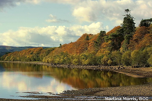
Lough Allen is a glacially formed wedge tapering towards the south where the water overflowed onto a wide plain now populated by many Drumlins. The Drumlins also occur as Islands in the lake, as shoals dangerous for boats, and as large underwater hills and deep valleys that we have sounded for fish. Many areas of the Lake contain much shallow water but there is a deep channel through the middle running from where the Shannon enters the Lake to where it leaves it, though both these areas have shoal deposits nearby. The mountains on all sides have formed Lough Allen. Provided the ice for the glaciers. Provided the rock that covers the shores and now provides the shelter or, alternatively, funnels the wind so that a calm lake may become choppy and very wild very quickly. (Don't we know it!) But on a calm day, with a blue sky, clear brown water, and hills with gently turning windmills, Lough Allen is one of the most beautiful places in Ireland, as can be seen from these images.
Geomorphology & Geology
Here we talk about the creation of the lake and the changes wrought that make it as we see it now. These are personal observations, based on some experience, but we can always be corrected or given new insights (just as recently happened with the photograph below). But there is no harm in raising ideas, in recording observations, and in providing material for others to examine and consider? Actual Bedrock is scarce around the shores of Lough Allen, very scarce. We tend to think of Lough Allen as largely surrounded by stony beaches, but these are loose boulders and pebbles. Examination shows these to contain diverse elements from different rock strata  and from further off places. The obvious implication is that these rocks were deposited around the lake from Ice sheets and that these ice sheets came off the surrounding mountains or, perhaps, further afield. However, by recall, it would seem that a preponderance of these rocks would be of sandstone. Shale would have broken up and there is little limestone nearby. At present major sandstone beds only occur at the tops of the mountains and they are small in area. However, the area may now be small simply because they were ground down by the Ice Age and there would formerly have been vast areas of upland plateau to provide material for Lough Allen's Drumlins and shoreline boulders? and from further off places. The obvious implication is that these rocks were deposited around the lake from Ice sheets and that these ice sheets came off the surrounding mountains or, perhaps, further afield. However, by recall, it would seem that a preponderance of these rocks would be of sandstone. Shale would have broken up and there is little limestone nearby. At present major sandstone beds only occur at the tops of the mountains and they are small in area. However, the area may now be small simply because they were ground down by the Ice Age and there would formerly have been vast areas of upland plateau to provide material for Lough Allen's Drumlins and shoreline boulders?
As regards the actual bedrock... at the lake shore this is all Carboniferous. But it is not limestone. The traditional Carboniferous limestone typical of this Era is found south of Drumshanbo but nowhere, to our knowledge, does it appear on the shore. So when you hear Carboniferous, don't think of limestones, alkaline water, burren type topography. The vast majority of the rocks that occur are shales and mudstones from the late early and early late Carboniferous. Also common are mudstone with a more solid structure. There are numerous beds of rock from various different ages reaching from the low level Bellavally Shales on the east to the massive sandstones of a newer age up on top of the mountains, e.g. the Bencroy Sandstone.
There is also a very thin but highly characteristic sandstone found in the lower shales. This outcrops along the Corry shore and is very obvious by its bright orange or tan colouring. This strata is called the Doobally Sandstone formation and is richly fossiliferous. This rock also contains some small signs of iron deposits (indicating a land souce for the rock) but also fossils which are marine! The strata is also extremely thin (20cm) but travels for miles across the countryside sandwiched in between the Bellavally Shale. So what we are talking about here is a brief but sudden change in sea level where fossils dying in the open ocean fell to the bottom and were quickly entombed by sandy deposits emanating from the nearby land. The significant Fossil here is a Nautilus species which still has a relative alive today! Also, this fossil is found only in the Sandstone at Lough Allen and not in the shale above or below even though these would be of similar age. So this fossil gives us a precise record of the time and the environment at the time of deposition.
Scenery & Wildlife.
These various rock formations and recent glaciation effects have left Lough Allen the way we see it... slightly different to other places and with its own unique features and qualities. Many people say to us...'there is something special about Lough Allen.' They never qualify it, and we don't know what it is either, but suggest that it is a function of the lake, the landscape, the quality of the water and the light. These are all different. Lough Allen has little urbanisation on the shore of the Lake; the sky can be very blue during the day and very black at night. Also, since the demise of the Celtic Tiger (one species we may be glad to lose?) the area is quiet and it is possible to hear the birds moving and migrating at night time. We sometimes talk about the three major lakes on the Shannon, but the other two (Lough Derg and Lough Ree) have a totally different geology and geomorphology. Lough Allen is definitely much more interesting!
The peace and the beauty, and also the fluctuating water levels and treacherous winds that make boating more hazardous, mean that Lough Allen is strikingly beautiful (in all its moods) but also serene and peaceful when it wants to be. This lends the area to the pleasures of relaxation, art and photography, research and study, more so than the more hectic forms of use seen in other parts of Ireland and other large waters internationally. It also may well be a factor in the amazing diversity of Wildlife found in the area. This needs to be looked for and studied or you may miss it, but in the area there are up to a dozen very rare plants and animals. These started us off on our path of research into the lake, and also our commitment to see these species protected and encouraged for further generations to study and appreciate. This is the main work of LoughAllenBasin.com and a job we take pride in. But this is discussed widely elsewhere and we are concentrating on earth, wind and ice here! (Go HERE for many wildlife stories.)
The Lake’s shores.
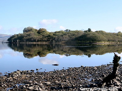 The area has a unique quality; also the nature of the shore, and the open lake itself, are different. The shoreline has several characters. It may be fringed by Alder carr. This is a name given to linear forests which occur typically around Lough Allen. They provide the unique views with a dark green line fringing the shore before leading into the brighter greens or Autumn oranges of other trees. Alder have a unique function in the ecology of the Lake and are an important and often ignored feature of the landscape. It is a beautiful landscape and very photogenic at all seasons. Many of the landscape photographs sprinkled through this article were taken on a beautiful Autumn day by the members of the Boyle Camera Club. This Alder carr is a significant feature in making the Lough Allen 'lakescape' different form many others. The Alder itself is a The area has a unique quality; also the nature of the shore, and the open lake itself, are different. The shoreline has several characters. It may be fringed by Alder carr. This is a name given to linear forests which occur typically around Lough Allen. They provide the unique views with a dark green line fringing the shore before leading into the brighter greens or Autumn oranges of other trees. Alder have a unique function in the ecology of the Lake and are an important and often ignored feature of the landscape. It is a beautiful landscape and very photogenic at all seasons. Many of the landscape photographs sprinkled through this article were taken on a beautiful Autumn day by the members of the Boyle Camera Club. This Alder carr is a significant feature in making the Lough Allen 'lakescape' different form many others. The Alder itself is a 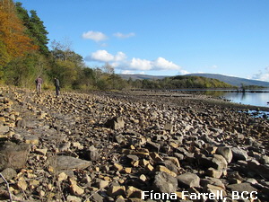 feature of the lake's creation and present form. feature of the lake's creation and present form.
Another common shoreline around Lough Allen is continuous boulder shore (backed up by alders). These are mainly rounded sandstone boulders and can be very spherical due to millennia of erosion by ice and water. A very significant part of Lough Allen's shore would be of this form. But it is a habitat that can support and shelter our rare plants and animals. e.g. Red Breasted Merganser, Irish Lady's Tresses, even the Blue-eyed Grass when the shore becomes stabilised and vegetated.
The third and somewhat different shoreline is the flat and either muddy or sandy shore of quiet bays. There is an interesting parallel between these shores and the fossil shore described above but we are not saying they are similar in the way they came about. The flat muddy shores with some scrubby Alder have formed the perfect habitat for our rare Orchid on the eastern shore of the lake where the majority of this relict species now occur. The occasional short, isolated, and quiet little sandy beaches are also a very popular area for the large numbers of Common Sandpipers that come to nest in Lough Allen every year, making the long journey from southern Africa. The piping call of these birds is one of the characteristic sounds of Summer in Lough Allen.
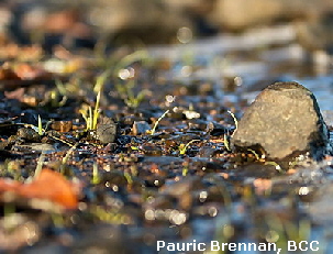 The habitation and the community surrounding Lough Allen are to a great extent traditional grazing based agricultural communities. There is no town on the shore of Lough Allen and all houses, both old and new, are built well back from the shore and well hidden by trees. One large Hotel exists at the southern tip of the lake but has now blended well and is an important part of the local community. We think it is great that little private onshore development has been allowed to proceed around Lough Allen but, for the sake of the community, we would support the idea of a Hi Tech no effluent high quality employer being attracted to the area. Such a pool of new blood might well contribute more rather than harm the survival of the delicate ecology of the lake. And would certainly immensely benefit the community and business of the area. Similarly, the mountains to the west of Lough Allen have major windfarms on them. We accept that people have different views on them, but they are there, can be a striking element in the landscape, and do provide a valuable contribution to the economy of the area and the country. The habitation and the community surrounding Lough Allen are to a great extent traditional grazing based agricultural communities. There is no town on the shore of Lough Allen and all houses, both old and new, are built well back from the shore and well hidden by trees. One large Hotel exists at the southern tip of the lake but has now blended well and is an important part of the local community. We think it is great that little private onshore development has been allowed to proceed around Lough Allen but, for the sake of the community, we would support the idea of a Hi Tech no effluent high quality employer being attracted to the area. Such a pool of new blood might well contribute more rather than harm the survival of the delicate ecology of the lake. And would certainly immensely benefit the community and business of the area. Similarly, the mountains to the west of Lough Allen have major windfarms on them. We accept that people have different views on them, but they are there, can be a striking element in the landscape, and do provide a valuable contribution to the economy of the area and the country.
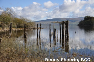 Many appealing vistas are seen around Lough Allen. You need to walk the shores, climb the mountains, go out in a rowing boat, land on the islands. Some of these islands are very close to shore. Some are never visited! Some you can walk to when the water is low. Trips to these island would be an attractive extra feature that could be established if parts of Lough Allen became a Nature Reserve. Some islands are rich in birds, some are not. Other lovely views of Lough Allen can be seen from the high ground to the west from the road below the windmills. It looks like an aerial photograph from there with a large part of the Lake laid out before you. Many appealing vistas are seen around Lough Allen. You need to walk the shores, climb the mountains, go out in a rowing boat, land on the islands. Some of these islands are very close to shore. Some are never visited! Some you can walk to when the water is low. Trips to these island would be an attractive extra feature that could be established if parts of Lough Allen became a Nature Reserve. Some islands are rich in birds, some are not. Other lovely views of Lough Allen can be seen from the high ground to the west from the road below the windmills. It looks like an aerial photograph from there with a large part of the Lake laid out before you.
Another facet of the scenery can be seen from low on the water on one of those still Summer days when the lake goes milky with only occasional riffles on the water, and when bubbles of gas rising in the shallow water, or fish jumping, is the loudest sound! Swim in it, canoe on it, take out a fishing boat but forget the sound of engines and just drift in the blue and brown water. Whatever you do, this is the most peaceful scenery you will come across. That, combined with better onshore research and relaxation facilities is, in our opinion, the future for tourism in this quiet and amazing area.
Man made structures are few around the Lake. There were coal mines, boat landing facilities, a Power station on these shores. Most of these structures are now gone. The islands have rarely been built on. A Church, as a traditional place of burial, exists on Church Island at the north of the Lake. A house, an arboretum and major earthworks were undertaken at Inishfail but now the beautiful and different species of trees are all that remain in this beautiful but hard to access 'island' at the Drumshanbo end of the lake. This is a unique place that could yet again play a part in the life of Lough Allen if wise counsels were to prevail?
Water
The quality of water in Lough Allen is good. It is brown; it is basically clean, and it is soft... sometimes warm and shallow, sometimes deep and dark. Unfortunately surfactants have now been introduced into the lake (perhaps by a less than wise Council rushing to modernise). Also certain parts of the north end of the Lake have been exposed to rubbish carelessly dumped into the Shannon flowing into the lake. Such blights, and the related very slight tendency to algal blooms in the Summer, are the only visual impairments on a pristine lake. But they are a blight, and blight is very infectious, and measures should be taken to correct these faults.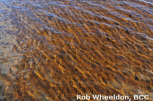
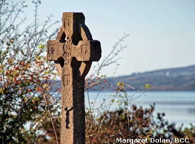 But, out on the lake, the water is always clear, sparkly and bubbly. Its brown and black colour derives from rivers draining from predominantly peat covered mountains. The lake bottom is bouldery near shore, often flat and muddy off shore, frequently very level but occasionally with surprising reefs and depths. We have been mapping the bottom contours all last Summer and now have a huge amount of data waiting to be processed. This work is because of our interest in rare and endangered species (as a reason for protecting and conserving this lake). Three species are very dependent on water depths and the quality of the water and its plankton. These would be a small Shrimp, Pollan (a fish species left over from the Ice Age) and the Red-breasted Merganser which tries tirelessly to breed in Lough Allen every year. But, out on the lake, the water is always clear, sparkly and bubbly. Its brown and black colour derives from rivers draining from predominantly peat covered mountains. The lake bottom is bouldery near shore, often flat and muddy off shore, frequently very level but occasionally with surprising reefs and depths. We have been mapping the bottom contours all last Summer and now have a huge amount of data waiting to be processed. This work is because of our interest in rare and endangered species (as a reason for protecting and conserving this lake). Three species are very dependent on water depths and the quality of the water and its plankton. These would be a small Shrimp, Pollan (a fish species left over from the Ice Age) and the Red-breasted Merganser which tries tirelessly to breed in Lough Allen every year.
It will be a while before we quantify and plot these depths but we have already learned much. The Drumlins found on the land and the islands, also exist underwater. Their shape and their stratification can be seen on a Sounder. They can suddenly rise very close to the surface from quite deep water so, if you don't have a sounder keep well inside the navigation markers! These drumlins also provide shallow and deep water in close proximity. Some of the underwater Drumlins are just as high as the land based Drumlins like Corry Island. Fish seem to love these slopes and we have also noticed very pronounced bands of small echos at different but constant levels within the water column. These echoes might simply reflect the 'thermocline' where warmed water floats on the colder water in hot Summer weather, or could they be shrimps which are known to rise and go down deep for night and day?
The deepest pocket in Lough Allen is a very small area of 41m. depth, south of Church Island. This seems to be surrounded on all sides by shallower water so, how did it form? Sounds like a glacial corrie to me! At the other extreme, the scary and variable shallows provide a valuable habitat for visiting birds. One small area of boulder and shingle near Cormongan was host this year to Lapwing, Curlew, Greenshank, Sandpipers, Common and Black-headed Gulls, Common Terns and in previous years held a pair of those incredibly rare Orchids _ unfortunately absent this year. All these rare plants and animals are dependent on the water level of this Spit remaining sufficiently low durning the breeding/flowering season. Thankfully, this year it did. But one of the main conservation worries in the area is the rapidly changing water levels which can totally eliminate rare species. This seems to be due to increasing Summer rains?
Island formation.
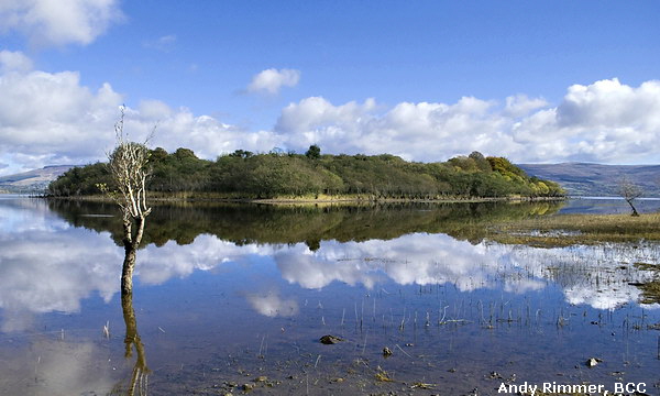
Would you believe, this was the topic we started out wanting to address? How have Lough Allen's islands formed, why do they change, why are some un-named or un-mapped? We started to study the islands this year as we had applied for a Heritage Council grant and had bought a boat with a view to surveying Birds to the same extent as we had surveyed the orchids in previous years. The Bird survey work is reported elsewhere in various ‘Trips aroung Lough Allen’. To understand island formation have a look at this excellent photograph. This photograph was obviously chosen as one of our Prize Winners for its sheer haunting beauty. But it also shows startling evidence of how islands form (and maybe disappear) in Lough Allen...
The first thing to say is that all islands, headlands and small lakeside hills, are of glacial origin. They are basically Drumlins, round piles of boulders, pebbles and sand, deposited where ice bearing rock has melted or been stopped in its tracks and unloaded a hill of detritus. They are not linear features but may often be elongated in the direction of travel. They have helped form islands in two ways.
Firstly, the Drumlins were placed above water level (then and now) and have always been islands or hills. Erosion by rain, frost, and lapping waves has extracted these boulders into the Lake. e.g. on the eastern shore of Corry Island. At this location if you look at the upper boulders well away from the shore they are angular (having only suffered short term erosion within the ice sheet) whereas the ones in the water and on the shore are smaller and very rounded from years of wave action. The second way of island formation relates to islands that are obviously recent in origin. How do we know this? Well some have no name, some are just reefs at present, others are not marked on ancient maps. One even, though large and fairly old does not even exist on current maps! 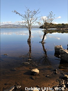
We call this the Alder and Boulder island formation hypothesis! Look at the picture above. In the foreground you will see some rocks with sticks jutting out of them. This could be either an island suffering erosion or starting to form? If the Alders are dead then it is probably the former! Alders have two unique properties. They will grow and survive in quite deep water. If the water gets too deep or stays deep for too long they will die. That's why you see many dead, or apparently dead, alder skeletons off the shore all around Lough Allen. Their other unique property is that they fix Nitrogen through microbial partners attached to their roots. Thus in a shore of rock and water they can produce their own source of essential Nitrogen. Like Clover in a pasture! This way they can colonise and hold on in a place where not many plants can get a foothold. By anchoring to the bottom they stabilise the bottom and cause silt and sand and other plants to settle around them.
As you go around the Islands of Lough Allen you will find many interesting geometric shapes. They can look man-made but they are regular and in areas where there is no record of buildings. These often puzzled us as they were frequent, in the centre of islands, and often had depressed centres. Normally they were empty but we eventually came across one onshore with a healthy Alder in the centre of the circle. What seems to be happening is that with water at a manageable level a new Alder sapling takes root... maybe in freak low water levels. This grows, survives and becomes immersed in water. During the Winter storms the Alder is strong enough to hold its ground but blocks the free movement of waves. These waves have the potential to shift quite large boulders and the wind may come from any direction. Boulders being rolled by the water are caught by the Alder and lodge up against it. This leads to a ring of stones being formed around the Alder and these stones gradually rise above the water level and produce a small exposed area of dry land. All the 'new' islands have these features, often towards the centre of the island. Depending on wind and water flow this little outpost may start to attract a sand, mud, or rock spit around it and these deposits will further encourage the settlement of Alders and other plants. After a few years such a place will be a perfect habitat for Ducks to breed. Before the islands become heavily covered with trees, these 'skerries' make a perfect breeding place for many other bird species.
The photograph below shows an example (from The Spit looking northwards towards Round Island and Long Island) of a circular structure and an associated large area of large and small boulders. This is a popular breeding area for Lough Allen’s Gulls and Waders:
 |
How do we prove this theory? Dunno! The pattern seems spectacularly consistent. Anyway, these are our two theories on the changing landscape of Lough Allen's islands and waters. In the photograph (at the top of this Section) you can also see a headland which is a Drumlin and then, to the right a series of alder covered islands disappearing into the south. The three main Islands at the north end of the Lake (Drummans, Corry and Church Islands) have a high core and and eroded bank around their edges. So these would seem to be eroded Drumlins that were always above water level. The three significant breeding islands to the south of the lake are all flat or even with a depressed damp centre and one of these is the one that is absent from the current OS map. We call it Jenny's Island!
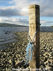 The main Islands. The main Islands.
 Moving from North to South let's list the Islands. Some of the names are well established, others are local names and one had no name. Drummans Island, medium height, elongated north-south, Mergansers seem to breed here, along with Common Sandpipers. White-fronted Geese visit in winter. Corry Island, featured at the start of this article, is a fairly high very intact Drumlin, not hugely significant for birds but with some interesting plants. A fine collection of glacially carried rocks showing different structures and from different ages can be seen on the eastern shore. Iron nodules can also be found here. The other main northern island is Church Island. An important area in community and historical terms with many centuries of history as a burial site. The Church is largely ruined but the island is still grazed and visited. Nature wise, breeding Ravens and Herons would be the main feature. Moving from North to South let's list the Islands. Some of the names are well established, others are local names and one had no name. Drummans Island, medium height, elongated north-south, Mergansers seem to breed here, along with Common Sandpipers. White-fronted Geese visit in winter. Corry Island, featured at the start of this article, is a fairly high very intact Drumlin, not hugely significant for birds but with some interesting plants. A fine collection of glacially carried rocks showing different structures and from different ages can be seen on the eastern shore. Iron nodules can also be found here. The other main northern island is Church Island. An important area in community and historical terms with many centuries of history as a burial site. The Church is largely ruined but the island is still grazed and visited. Nature wise, breeding Ravens and Herons would be the main feature.
A smaller island, Gull Island (and some rocky shoals) occur off Corry Point. This is a very significant breeding island for Lesser Black-backed Gulls and Common Gulls. The Lesser Black-backs are the dominant species and totally take over the island during the Summer. This year Mergansers had also attempted to breed and we saw three young birds nearby but we also saw many predated eggs... breakfast for the Gulls! But both the Common and Lesser Black-backed Gulls reared young here.
Moving south, the other main islands are situated off Cormongan and to the south of it. Long Island faces Cormongan Harbour. It is a long elongated island with many trees mostly of Alder and Willow and much undergrowth but seems little used for breeding water birds. There is probably one pair of Common Sandpipers there and both Mallard and Mergansers seem to use the secluded west shore of the island for resting and preening. It does not seem to hold a breeding pair of Mergansers. Just 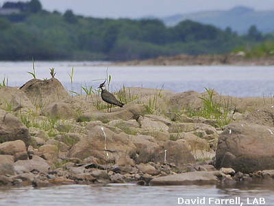 to the west lies Round Island which, as its name implies, is not elongated in a north-south direction. Round Island is another important colony for Lesser Black-backed Gulls. They have bred there successfully this Summer but have done so on the basis of attacking another bird colony a few hundred metres to the south! Mergansers have also bred here with one young bird being seen towards the end of the Summer. to the west lies Round Island which, as its name implies, is not elongated in a north-south direction. Round Island is another important colony for Lesser Black-backed Gulls. They have bred there successfully this Summer but have done so on the basis of attacking another bird colony a few hundred metres to the south! Mergansers have also bred here with one young bird being seen towards the end of the Summer.
Not an Island but very significant for birds, is the place we call The Spit. This is a shallow reef, almost covered when water levels are high, to the south of Cormongan. It is an intensive breeding area for a large Common Gull colony, some Black-headed Gulls and four Common Terns this year. The Terns are a very attractive species which it would be lovely to have nesting here. As are the Common Gulls which are doing pretty well. A pair of Common Terns spent the Summer here but were continuously disturbed by visiting Lesser Black-backed Gulls from Round Island nearby. It is not known if these Terns have tried to establish themselves here in previous years. They will have difficulty in breeding here with the disturbance by the Black-backed Gulls. Also the Black-headed Gulls nested later than the Common Gulls and were also more put upon by the Black-backs. Interestingly, the two Terns started to prospect around Jenny's Island at the end of the season where disturbance by the big predatory Gulls was almost non-existent. The Spit was also the most isolated and barren area that Spiranthes (the Orchid) was found during the good year of 2008.
Picture on the Left shows a Lapwing, a now rare bird on Lough Allen, at its favourite resort_ The Spit.
A bit further south lies what we call Jenny's Island. The most interesting thing about this Island is that, not only is it not named but it doesn't even appear on the OS Discovery Maps, despite being one of the bigger islands in the Lake? It is low lying, with a marshy patch in the centre, all boulders and pebbles, intensively covered with Willows and Alders some of which are obviously quite old. An important breeding area for Sandpipers with many young being seen together on an off-lying shoal in the Summer. Mergansers visit this island but are not as rigidly attached to it as other breeding islands such as Round Island, Gull Island, and indeed the Rossmore inlet! Two other small islands, often attached to the mainland, exist in the channel north of Drumshanbo and to the south of Inishfale. We call these Spiranthes Islands as they were formerly a good flowering area for Irish Lady's Tresses (Spiranthes romanzoffiana).
Jenny’s Island looking southwards with the east shore of Lough Allen on the left and Inishfail on the right.
Shoals and Skerries
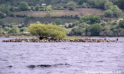 Even some of the smallest patches of rock appearing above the surface of Lough Allen, will often have a tree on them _ an Alder tree! If it wasn’t there we mightn’t even know the rock was there, as is the case with a small treacherous reef just off Gubarusheen, Cormongan! But, those apart, maybe it is fair to define islands as those bodies with a good ground and tree cover and the skerries as low-lying rocky patches of ground which have few or stunted trees (like Bonsai’s). The islands with dense cover are beloved of the Ducks and Sandpipers and the bare skerries are favoured by most of the Gulls. However, the Lesser Black-backed Gulls nest on islets that have a reasonable amount of tree cover. There are many skerries (or very small patches of rock) which become visible during the Summer and may host individual or small groups of breeding Gulls as well as the main colony on The Spit Even some of the smallest patches of rock appearing above the surface of Lough Allen, will often have a tree on them _ an Alder tree! If it wasn’t there we mightn’t even know the rock was there, as is the case with a small treacherous reef just off Gubarusheen, Cormongan! But, those apart, maybe it is fair to define islands as those bodies with a good ground and tree cover and the skerries as low-lying rocky patches of ground which have few or stunted trees (like Bonsai’s). The islands with dense cover are beloved of the Ducks and Sandpipers and the bare skerries are favoured by most of the Gulls. However, the Lesser Black-backed Gulls nest on islets that have a reasonable amount of tree cover. There are many skerries (or very small patches of rock) which become visible during the Summer and may host individual or small groups of breeding Gulls as well as the main colony on The Spit
Biodiversity impact of the Islands
As you can see from this brief summary the Islands of Lough Allen are very important to its biodiversity. Without the islands Lough Allen would have much fewer species of breeding birds. It is unusual to find Lough Allen’s rarest plant on the islands but that we did in 2008. Funnilly enough this ‘island’ was The Spit and, as its name implies it is attached to the mainland at low water levels. Water level is crucial to the survival of this the rarest of Lough Allen’s plants. Also being close to the mainland, cattle do go across to The Spit. Despite what one might expect these seem to disturb neither the Birds or the Orchids much! The Orchid is typically associated with shoreline areas where cattle and horses regularly graze. So this grazing seems beneficial to the continuance of this rare species on Lough Allen. Funnily enough, we have also noted that when the Cattle are on The Spit the visiting of the area by predatory Lesser Black-backed Gulls seems to be reduced and the resident breeding birds are much less fractious. Presumably the odd egg is trampled but this is much less than the damage inflicted by the marauding Gulls from nearby Round Island. Further south the two small islets (we call Spiranthes Islands) also had good populations of this Orchid in the peak year of 2008. These islands are also stony, have a good Alder cover, are disconnected from the mainland for a lot of the time, and are also visited by grazing animals (Horses mainly).
Below: The very first 2 Orchids we found... on the low treeless rocky Spit!
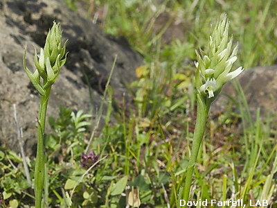 These low-lying Islands and skerries are also stabilised by Alder. This is not a rare tree but without it the nature and diversity of the Lough Allen environment would be reduced or considerably different. Alder Carr, as a habitat, is an environmental feature of Lough Allen. These low-lying Islands and skerries are also stabilised by Alder. This is not a rare tree but without it the nature and diversity of the Lough Allen environment would be reduced or considerably different. Alder Carr, as a habitat, is an environmental feature of Lough Allen.
The Islands of Lough Allen are little visited and are probably at little risk from human intrusion. However, this Summer, we have frequently seen severe levels of foaming in the water often seeming to blow up from the south. Severe but small algal blooms have been seen at Spiranthes Islands and at the Cormongan shoreline. Wind and wave patterns might suggest that this material is coming from the Drumshanbo end of the lake, the foaming does not seem to have any natural source, and it seems to be increasing over the years. Is this, possibly, a problem emanating from the water treatment works at Drumshanbo. Lough Allen is a beautiful, and largely clean habitat, with many unique breeding plants and animals. We must not let threats from our way of life destroy their way of life?
The Biodiversity of Lough Allen can be maintained by careful management, avoidance of any damage through pollution, development or failure to implement the right measures, and by a thoughtful and imaginative strategy to protect and provide for our existing animals and plants... partly from themselves! (Many Birds are savagely preying on one another and, while this is natural, it may be preventing such species as Common Terns becoming established as a breeding bird here and may also be putting Lough Allen’s charismatic bird, the Red-breasted Merganser, at risk.)
That concludes our introduction to the Islands of Lough Allen. I hope you find something of interest and we are delighted to be able to use this study as a vehicle for featuring many more of the brilliant photos that came from members of the Boyle Camera Club. Many thanks, Ladies and Gents!
Remember.......... THE4R’s
|
Research...
|
Rest...
|
READ...
|
Relax...
|
|
|
|
|
|
|
Lough Allen Basin
|
RAMADA Hotel Lough Allen
|
Outdoor Photography magazine
|
Carrick Cineplex
|
|
SPONSORS of “Photographing Lough Allen” in conjunction with the Boyle Camera Club.
|